
Sun or Jamming? A Free Space Weather Forecast for Comms Officers
SkyLinker's new SCOR service turns NOAA and NASA data into a three-day risk color for GNSS and satcom systems. Volodymyr Stepanets explains how it reads three past storms.
A Forecast Built for the Radio Operator
In May 2024 the strongest geomagnetic storm since 2003 hit Earth, a G5 on NOAA's five-step scale. Starlink users reported degraded service, yet every band chart said Ku and Ka should barely notice a storm. So what was breaking the link: the Sun, enemy electronic warfare (EW), or the terminal itself?
Ukrainian analysts at SkyLinker now offer a first answer in seconds. They have launched, in beta, live.scor.skylinker.io, built on their SCOR methodology (SkyLinker Comms Outage Risk). It translates raw space weather metrics into risk for specific communication and navigation systems. The page is free, needs no registration and adapts to phones.
It shows two things: current conditions on the Sun, in the solar wind and in Earth's magnetic field, and a forecast for today plus two days. Nine systems are covered: GNSS, Starlink, OneWeb, Amazon LEO, Iridium, Intelsat FlexMove, KA-SAT/Tooway, Konnect VHTS and Thuraya. A separate block rates eight radio bands over Ukraine, from HF to Ka. Data is checked eight times a day, and the forecast draws on NOAA SWPC, GFZ and NASA CCMC, always taking the most pessimistic of the three.
Reading the Card in One Minute
Each system gets one color per day, and each color is an instruction, not a storm rating: green means work as usual; yellow, check that your backup is alive; orange, deploy the backup and duplicate what matters; red, make the backup your primary; dark red, plan work without this system.
Behind the color sits a split that matters. The cell background shows risk from the ionosphere, which disturbs radio signals while the storm is happening. Dots show risk to the satellites themselves, which can linger for days afterwards. Icons name the cause. Merging the two into one score, SkyLinker argues, would hide the question operators actually need answered: what exactly will break, and why.
May 2024: Satellites, Not Airwaves
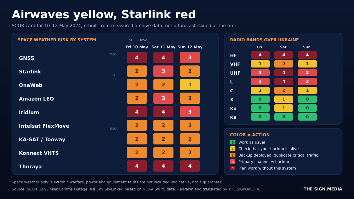
SkyLinker re-ran its model on NOAA data for 10 to 12 May 2024. On 11 May the Ku airwaves for Starlink were only yellow, but the overall result was red. The danger came from the satellites. According to the source, the storm heated and expanded the upper atmosphere, and drag at Starlink altitudes rose three to five times. Satellites slowed, the constellation maneuvered, and users saw delays and short drops.
The L-band told a harsher story. GNSS, Iridium and Thuraya were dark red on 10 and 11 May, as was HF. An unstable ionosphere makes L-band signals flicker and pushes GNSS errors up to loss of lock. For drones relying on satellite navigation and for long-range radio, this was the riskiest window.
January and October 2024: Radiation and Backups
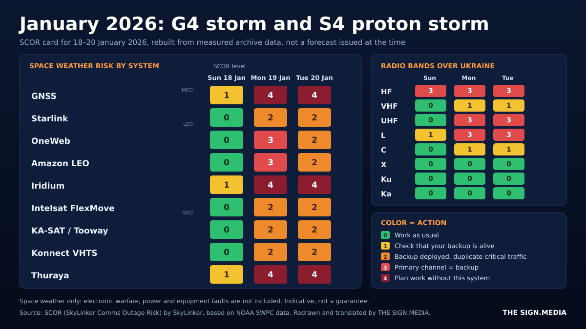
On 19 to 21 January 2026, a G4 geomagnetic storm arrived together with an S4 radiation storm, which the source calls the strongest since 2003. Protons striking onboard chips can flip a bit or reboot a satellite subsystem.
The meteorological satellite GOES-19 reportedly suffered sensor faults and system restarts. SCOR's card shows the risk building from a calm first day, then rising for every system once the coronal mass ejection arrived. By 21 January the airwaves for Starlink and Amazon LEO were green, yet the systems themselves stayed orange.
After a strong storm, SCOR keeps low-orbit systems at yellow or above for up to two more days, because the upper atmosphere settles slowly. The lesson: a green band does not mean a green system.
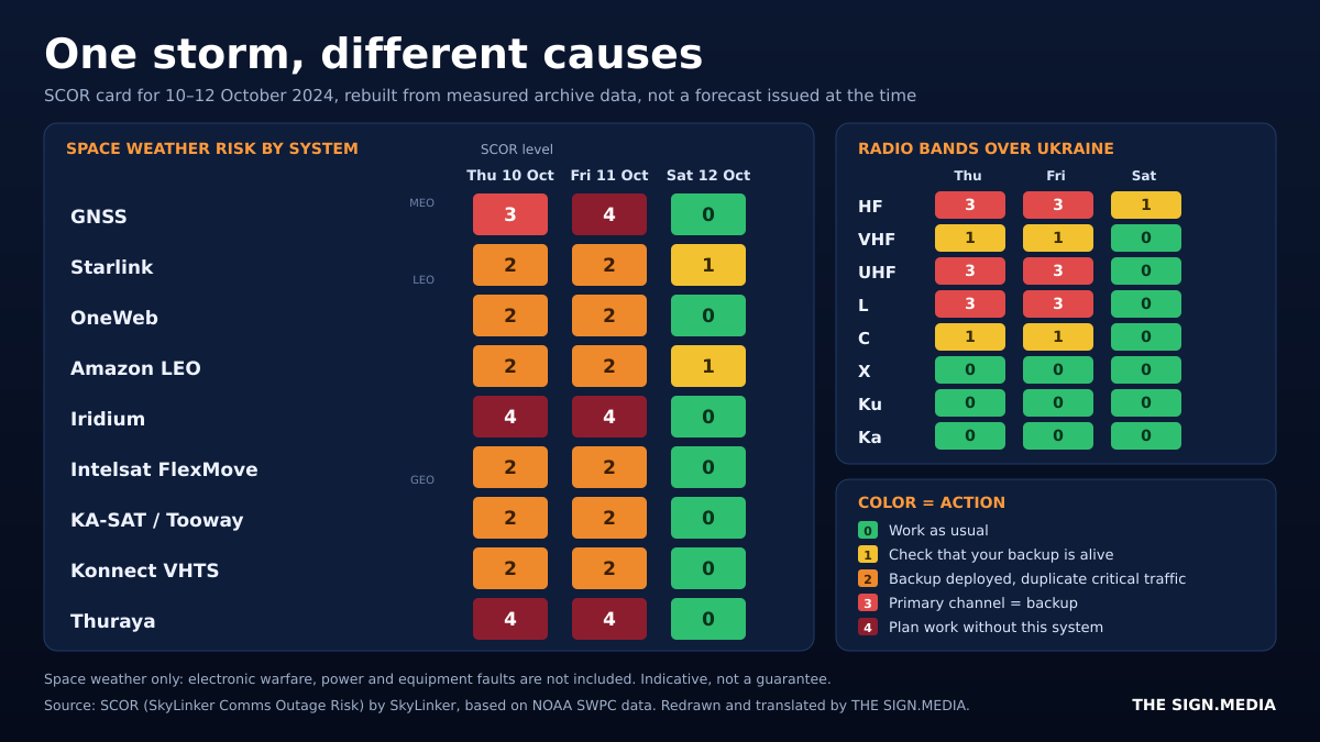
The G4 storm of 10 to 11 October 2024 shows how one event hits systems differently. Low-orbit constellations suffered from drag. OneWeb, at around 1,200 km, did not, but faced radiation and surface charging.
Geostationary systems faced charging and exits from the magnetosphere. Ku and Ka systems were orange, GNSS, Iridium and Thuraya dark red. The practical rule: choose a backup on a different orbit or a different band, so that one cause is unlikely to take down both. That day, nothing was better than orange, so critical traffic should have been duplicated.
When a Storm Becomes Cover for EW
According to the original article, in May 2024 an adversary used a week of geomagnetic disturbances to deploy a new EW system against Starlink, counting on natural degradation to mask the jamming. The source says space weather research helped separate the signatures of jamming from those of the storm, that the adversary's success was very limited, and that the source of the interference was found and destroyed. These details come from the original article alone and are not independently verified here.
The broader point stands either way: a storm should not become an alibi for EW or for faulty equipment. SCOR offers a quick rule. If your system is green, space weather is an unlikely culprit, with GNSS as the exception because local ionospheric disturbances can appear even on green. If it is any other color, natural degradation is possible, but jamming is not ruled out.
Honest Limits of a Beta Service
The historical cards were rebuilt from measured data, not from the forecasts available at the time. In live use, quality depends on upstream agencies: a flare nobody predicted, SCOR cannot predict either.
SkyLinker says validation on 2017 to 2026 data showed every 2024 storm that truly degraded Starlink scored at least yellow, but some local GNSS disturbances and Starlink degradations after weak storms still need calibration. Thresholds are being tuned, and updates may be interrupted.
For operators the value is clear: ten seconds before a mission to see three days of risk, a backup deployed early, and a first answer to "Sun or EW?". Field testers of military equipment gain the same: a way to avoid blaming the product for what the Sun did, or the Sun for a product flaw. SkyLinker is also piloting Signal bot alerts in closed military communication communities, and asks users to report where the forecast matched or missed reality, without coordinates, unit names, frequencies or EW indicators.
Conclusion
Check the color before the mission, not after the outage, and keep a backup on a different orbit or band: it is the cheapest insurance against the Sun.
Author: Volodymyr Stepanets, MilComDev Technical Evangelist | SatCom, PNT, MANET
Source: adapted and translated from the Ukrainian article "Чи підведе зв'язок завтра? Тепер на це є прогноз SCOR" ("Will the connection fail tomorrow? SCOR now has a forecast for that"), published by SkyLinker on 15 November 2026: https://www.skylinker.io/p/scor-live-space-weather-comms-risk-ukr.